
Cape Horn Loop Hike
- Tiff

- Jan 7
- 3 min read
Experience the Columbia River Gorge on the Washington Side of the river, only about 25 minutes from Vancouver, WA!
Hiking the Cape Horn Loop
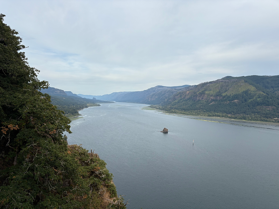
The Cape Horn Loop Hike is a great trail that’s a pretty beginner one for well-travelled hikers and a moderate hike for less seasoned hikers! Cape Horn is one of my favorite local hikes. It provides awesome views, and it’s super close to home. It’s also a good one to take visitors to because there’s something for everyone! Some big inclines, waterfalls, top-of-the-Gorge views, a small “scramble” (just a rocky patch, but it’s good practice), a road walk, and more!

Milage and Elevation
Based off my recording:
Distance: 7.3 miles
Elevation Gain: 1,400 feet
An important note: The southern part of the loop is closed from February 1 - July 15 for peregrine falcon nesting.
This hike is also great because you don’t have to do the whole loop! You can split this into out-and-back sections since there are three parking options!
Parking Options:
Lower Cape Horn Trail: The great thing about this hike is that there are different sections you can do! You can park off Highway 14 for a short walk to a viewpoint of one of the waterfalls! This trailhead is called Lower Cape Horn Trailhead.
Salmon Falls Park & Ride: You can also park at the official Cape Horn trail head at the Salmon Falls Park & Ride.
Stark Road: this isn’t an official parking spot, but you can park here and walk to the upper Cape Horn overlook!
Highlights:
A beautiful waterfall in the lower section
Panoramic views of the Columbia River Gorge
Hiking through old-growth trees
Hiking over volcanic rock
Views of basalt rock pillars on the Columbia River shore


How I Hiked The Cape Horn Loop
I decided to start at the park & ride and take the route south. This is the opposite direction of what I’ve read, but I hadn’t done the south section yet and wanted to start with that! It was brilliant! The hike starts with a little muddy section and a tunnel that allows you to go under Highway 14.

This leads to Cape Horn Road, which you follow for about a mile. At the bottom of the paved section, you get to the harder part of the trail! This is where you go pretty uphill. It is beyond beautiful. Since this was my first hike of 2026, that means January, obviously, and it’s winter! Winter in the Gorge means a lot of rain, which means flowing waterfalls! Oh my gosh, you guys, it’s amazing. I’ve only ever done the SR 14 hike up to the Nancy Russell Overlook- also a great hike- but this part was so stunning and pretty challenging. It involved climbing up and over, and going behind a waterfall! It was pretty incredible.
Once you get up out of the steep section, you must check out the Cape Horn Waterfall Overlook. From there, hike up to see some more lookout points (follow the foot trail, not the horse trail). You’ll get to the Nancy Russell Overlook, which is another spectacular panorama of the Gorge.

Nancy Russell is one of my inspirations. She is the reason the Cape Horn trail exists. If it wasn’t for her, the great, beautiful Cape Horn would be a subdivision! Thank you, Nancy!
Continue east up the Gorge, and after about a mile and a half, you’ll make it to a couple of pretty insane viewpoints you walk out to. It’s a little sketchy, but just stay away from the edge, and you’ll be fine! You finish the hike out with another mile and a quarter, and you’re back at the parking lot!
Of course, this way is the “opposite” way. Make this hike your own! Start by going up to the right at the park and ride! Make it a short hike by doing an out-and-back section. Whatever you do, have fun with it!
For more information about the trail, check out the Washington Trail Association’s page on Cape Horn Trail! They do amazing work! Happy Hiking!


https://keonhacai5.net/ dạo này mình thấy nhiều người nhắc nên cũng bấm vào coi thử cho biết. Mình không đọc sâu đâu, chủ yếu lướt qua xem giao diện có dễ nhìn không. Cảm giác đầu tiên là trang sắp xếp khá ngăn nắp, nhìn không bị rối kiểu nhồi chữ. Mấy phần thông tin họ để theo dạng khối nên mắt mình bắt nhanh, kéo xuống cũng đỡ mệt. Mình cũng để ý cái menu đặt khá rõ, chuyển qua lại vài mục thấy tiện, không phải tìm vòng vòng. Nói chung kiểu trình bày này hợp với người chỉ muốn xem nhanh, vì các khung nội dung và bảng cột trên trang nhìn gọn và sạch.
sun win mình vào thử cho biết vì thấy nhắc hoài, kiểu xem giao diện trên điện thoại có ổn không thôi. Vừa mở lên là thấy tiêu đề “cổng game chính thức 2026” đặt khá rõ, nên đỡ bị lăn tăn là đang vào nhầm trang. Trang này trình bày theo dạng các khối nội dung, nhìn gọn và dễ quét mắt, lướt xuống một chút là nắm được ý chính chứ không bị chữ dồn dập. Mình cũng để ý họ nói hệ sinh thái trò chơi phong phú với trải nghiệm hiện đại, nhưng mình chưa kịp bấm sâu vào từng mục. Nói chung cảm giác dùng khá nhẹ, thao tác không bị rối. Mấy khối nội…
1hitclub.io mình ghé thử vài phút cho biết vì thấy bạn bè nhắc, kiểu vào xem giao diện có dễ dùng không thôi. Ấn tượng đầu là trang bố cục khá thoáng, các khối nội dung tách bạch nên mắt mình không bị “ngợp” như mấy site nhồi chữ. Mình hay bị lười tìm nút, mà ở đây cái menu để khá lộ, bấm qua lại giữa các mục thấy mượt, không phải kéo lên kéo xuống nhiều. Có mấy phần thông tin trình bày gọn theo dạng cột nên liếc nhanh là hiểu ý chính, không rối. Nói chung cảm giác như họ ưu tiên cho người mới vào xem một lượt là nắm được đường đi, nhất là…
hitclub6.it.com bữa lướt thấy người ta nói nhiều nên mình bấm vào coi thử cho biết thôi. Mình không rành mấy vụ game gủng nên chủ yếu xem trang làm có dễ nhìn không, có bị rối mắt không. Cảm giác đầu tiên là giao diện khá thân thiện, chữ nghĩa rõ ràng, kéo xuống một đoạn là nắm được họ đang giới thiệu gì về Hitclub chứ không kiểu nhồi nhét lung tung. Mình cũng để ý bấm qua lại mấy mục thì tải khá nhanh, không bị đứng hình hay chờ lâu. Nói chung nhìn như họ có chăm phần trình bày, nhất là mấy khối nội dung được chia theo cụm và tiêu đề heading đặt gọn…
rophim dạo này mình thấy nhiều người share nên tò mò vào nghía thử cho biết. Ấn tượng đầu là trang mở lên khá lẹ, vừa vào đã thấy danh sách phim hiện ra luôn chứ không bị mấy lớp hiệu ứng che màn hình. Mình không rành đánh giá phim hay dở, chỉ thấy cách họ bày nội dung gọn gàng nên lướt tìm cũng đỡ mệt. Có mấy mục kiểu phim mới phim hay nhìn phát hiểu ngay, bấm qua lại không bị rối. Thử xem trên điện thoại thì kéo xuống mượt, chuyển mục cũng ổn, không bị giật lag khó chịu. Nói chung cảm giác dùng khá “nhẹ”, và phần các khối phim được chia theo…